|
|
|||
|
BIG THICKET |
|||
|
Map of the Big
Thicket Area & |
|||
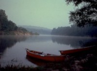 The
Big Thicket has been called the "biological crossroads of America" and
the Ark of America. The diversity of species and terrains are what make the Big
Thicket a special place. Hardwood pine forests are next to cypress forest, along
with blackwater swamps and meadows. The
Big Thicket has been called the "biological crossroads of America" and
the Ark of America. The diversity of species and terrains are what make the Big
Thicket a special place. Hardwood pine forests are next to cypress forest, along
with blackwater swamps and meadows.The Big Thicket National Preserve contains 85 types of trees, over 1,000 flowering plants, including 20 orchids, plus nearly 300 types of birds, along with more than 50 reptile species, including alligators. Prior to being heavily logged the Big Thicket covered around 3.5 million acres. 300,000 acres remain. Of those 300,000 acres 84,000 make up the Big Thicket National Preserve. |
|||
|
Logging the Big Thicket forest began in the 1850s.
A narrow-gauge railroad was added in 1876, which increased the logging and devastation to the Big Thicket Timberland. During the Great Depression the federal government bought parcels of land from timber companies, attempting to keep them in business. But, when the Great Depression ended the government held on to the land. In 1974 Congress made the Big Thicket a National Preserve, which stopped the logging. |
|
||
|
Due to the delicate nature of the Big Thicket, no cars are allowed beyond designated points. When you get to those designated no car points you will find hiking trails. |
|||
|
|
|||
|
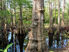
TURKEY CREEK UNIT Pitcher Plant Trail: This trail wanders through a mixed
pine forest, eventually bringing you to the edge of a savanna wetland where you
will see several carnivorous plants, including pitcher plants.
BIG SANDY CREEK UNIT Beaver Slide Trail: This is a 1.5 mile loop that takes you by a series of ponds made by beaver dams. Here you will find several fertile fishing holes on Big Sandy Creek. Woodlands Trail: You have 3 trail options here, loops of various lengths, 5.4 miles, 4.5 miles and 3.3 miles. The trails ramble through a variety of terrains. Big Sandy Creek Horse Trail: Designated for horse riding, mountain bikers and hikers can also use this 18 mile round trip trail through upland pine forests, crossing Simons Branch into a forest of sweetgum, basket oak, hornbeam and holly. BEECH CREEK UNIT Beach Woods Trail: A 1 mile trail through stands of magnolia and
beech trees. |
|||
|
|||
|
|
|||
|
Visit
our Eyes on Texas Blog to make a comment or share info about the Big Thicket |
|||
|
|
|||
|
|
|||
| HOME TEXAS TOWNS PARADES | |||
|
|
|||
| BIG BEND COUNTRY | |||
| GULF COAST PINEY WOODS | |||
| PRAIRIE & LAKES HILL COUNTRY | |||
| SOUTH TEXAS PLAINS | |||
| PANHANDLE PLAINS | |||
|
|
|||
| Conroe Huntsville Jefferson | |||
| Nacogdoches Marshall Gilmer | |||
| Rusk Tyler Kilgore | |||
| Big Thicket National Preserve | |||
 Due to the way the government came to own the Big Thicket land
the park is a long string of individual units from just north of Beaumont,
centered around Hardin county, extending to Jasper, Tyler, Jefferson, Liberty,
Orange and Polk counties. 12 units make up the Big Thicket National Preserve.
The main park tourist office in at the Turkey Creek Unit, 8 miles north of
Kountze.
Due to the way the government came to own the Big Thicket land
the park is a long string of individual units from just north of Beaumont,
centered around Hardin county, extending to Jasper, Tyler, Jefferson, Liberty,
Orange and Polk counties. 12 units make up the Big Thicket National Preserve.
The main park tourist office in at the Turkey Creek Unit, 8 miles north of
Kountze.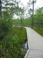 Shadow
Trail: This trails claim to fame is its vibrant display of wildflowers
blooming from late spring through summer. There is a 1 mile hike and a
handicapped accessible half mile trail.
Shadow
Trail: This trails claim to fame is its vibrant display of wildflowers
blooming from late spring through summer. There is a 1 mile hike and a
handicapped accessible half mile trail.