|
|
|||
|
LOOKING BACKWARDS IN TEXAS: |
|||
|
|
|||
|
click a thumbnail to view a photo
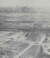
A few decades after this photo was taken this would become the world's most famous view of Dallas. In this photo we see the start of construction of the bridge across the Trinity River for what eventually became I-30, looking at the downtown Dallas of 1956. Obviously prior to the construction of the skyscrapers which now make up downtown Dallas, and the Reunion Tower and Hotel, which became the symbol of Dallas in the public imagination, after the TV show Dallas caught the world's attention. |
||
|
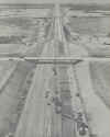
It was first called the Dallas/Fort Worth Turnpike. A toll was charged. Then it became I-20. Then, when another I-20 was built a few miles south it became what it is today, I-30. Here we see the Dallas/Fort Worth Turnpike under construction in 1956. |
||
|
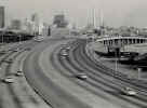
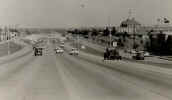
Here we are a few years further in the future, in the early 60s. This is the Stemmons Freeway, also known as I-35E, we are looking south here, towards downtown Dallas. Notice how big the freeway looks and how few cars are on it. And all the skyscrapers under construction. | ||
 |
I-35, north of Dallas, early 60s. No suburban congestion noticed at this point in time. | ||
 |
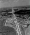
In what is now the north part of the D/FW Metroplex, in Collin County, south of McKinney. We are looking at SH-75 heading south towards Dallas, the road intersecting SH-75 in this view is SH-121. The view from this location in 2002 is no longer rural. |
||
 |
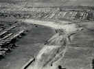
Now we are back on what is now I-30. If anyone has ever exited from I-30 onto Collins Road and wondered why such an exchange would have been built with those huge loops and no regular freeway cloverleafs, well from this view it seems likely the designers figured they had all the land in the world to work with, so why not. This photo is from sometime in the 1956-58 era. Six Flags would have been operating just a slight distance to the east, but you would never guess that this is Arlington from the totally rural look of this photo. | ||
|
|||
|
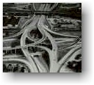
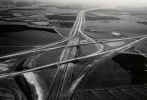
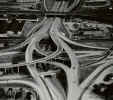
In northeast Tarrant County (the county Fort Worth is in) there is an intersection of several highways. I-820, I-21, I-183 and SH-26. In the past few years this exchange was rebuilt into a massive new, well-functioning Mixmaster. In this photo from the early 60s, we see the first I-820/121/183 Mixmaster under construction, the one the new one replaced. This is near the border of Hurst and North Richland Hills, near the Grapevine Highway (SH-26), near what is now the Northeast Mall. |
||
|
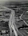
This photo is from 1958, on what was called the Fort Worth Expressway, and would later be known as I-30. We are near the Hulen Street exit here, heading east towards downtown Fort Worth. In 2002 traffic can be heavy at this point with people trying to exit to Hulen Street to go to Central Market among other things. |
||
|
Here we see the original Mixmaster #1 in downtown Fort Worth in the late 1950s, at the intersection of I-35W, I-30 and SH-287. Fort Worth built the first multi-level freeway exchange in the Dallas/Fort Worth area. Locals call it a Mixmaster. The Mixmaster served well for a few decades. But in the early 1990's a new Mixmaster and re-alignment of I-30 began. A 12 year project which made much of downtown Fort Worth look like some sort of war zone. Like Berlin after WWII. | ||
|
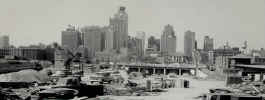
Here we see a new section of the old Mixmaster under construction in the early 60s, with downtown Fort Worth looking forlorn in the background; no skyscrapers---the Plywood Skyscraper/Tin Can Tower and much more was yet to be built. |
||
|
That's it for road photos for now. |
|||
|
|
|||
|
|||
|
|
|||
| HOME TEXAS TOWNS PARADES | |||
|
|
|||
| BIG BEND COUNTRY | |||
| GULF COAST PINEY WOODS | |||
| PRAIRIE & LAKES HILL COUNTRY | |||
| SOUTH TEXAS PLAINS | |||
| PANHANDLE PLAINS | |||