|
|
|||
|
Washington's |
|||
|
|
|||
|
|||
|
|
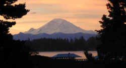
Ā Āclick thumbnails to enlargeĀ Mount Rainier |
||
|
|
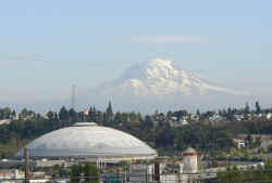
The Tacoma Dome, dwarfed by Mount Rainier.ĀThe Tacoma dome is the world's second biggest dome made with wood. After the Kingdome died the Tacoma Dome became the biggest dome in the state of Washington. Yakima built the SunDome in 1990, but it is quite a bit smaller than the Tacoma Dome, originally the SunDome was to be called the QueenDome in an eastern Washington sort of homage to the now deceased Kingdome. SunDome seems a much better name for a dome in a town which describes itself as the Palm Springs of Washington. | ||
|
|
click
here to view video of
|
||
|
|
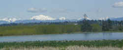
Cascade Mountain Foothills
Just north of Everett, south of Marysville on Interstate 5 looking.Ā Mount Baker is that big white thing to the north.Ā |
||
|
|
Mount Pilchuck is the tallest mountain you see in this view of the Cascades from I-5 just north of Everett. We'll get real close to Mount Pilchuck below. To do that we'll need to leave I-5 and drive east to Granite Falls and the Mountain Loop Highway | ||
|
|
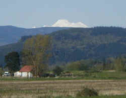
Mount Baker
Mount Baker and the Cascade Mountain foothills east of Mount Vernon near the Nookachamps on the way to Big Lake. We are driving north on Interstate 5 looking west. |
||
|
|
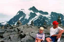
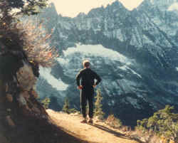
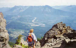
Mount Shuksan In late summer the snows of winter have melted enough that you can usually drive Mount Baker Highway to its very end, past the ski area, ending in a large parking lot. From the parking lots you can take many different hikes, including trails that take you on the north side of Mount Baker. The pair you see in this photo, brothers now living in Arizona, and who you will see below exploring an ice cave, are sitting on top of Tabletop Mountain with Mount Shuksan looming behind them.Ā |
||
|
|
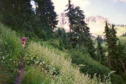
ĀChurch Mountain There is a point on the Mount Baker Highway when you look to the north and you see this emerald green meadow that appears to be almost vertical. When you see this you want to see it up close. The hike to the summit of Church Mountain lets you do that. But be warned, this is not an easy hike. You find the trailhead by driving Mount Baker Highway 7.7 miles past Glacier, take a left on East Church Road and in about 10 miles you'll be ready to hike. Be sure to bring a lot of water and bug spray. The bugs can be brutal. After what seems like endless switchbacks and steady elevation gain you break out of the Evergreens onto the meadow you'd seen from below. You can now look down on the highway you were looking up from and the cars will look like ants. It is a long traverse, ever higher across the meadow. The trail turns rocky as you leave the meadow. Your goal is the top of Church Mountain where you'll see the remains of a lookout that sat on top of the pointed pinnacle that is the summit of Church Mountain. It is very steep, a cable that helped hold down the lookout helps you pull your way to the top. This is not for the faint of heart or the acrophobic. The view is one of the best you'll ever see. North to Canada, to the southeast Mount Baker and Mount Shuksan and all the surrounding peaks. The hike is 8 1/2 miles roundtrip with 4500 feet elevation gain. It feels like more. Wear good hiking boots. Did we mention the need for bug spray? |
||
|
|
Excelsior Mountain From the summit of Excelsior Mountain you can look down the Nooksack Valley all the way to the Puget Sound lowlands, you can see Mount Baker and the southern portion of the British Columbia Coast Range. In July the meadows are full of flowers. In September you can enjoy the colors of fall and berry picking. You can find the trailhead by driving Mount Baker Highway 2 miles past Glacier to Canyon Creek Road, take a left and go a bit over 14 miles to the trailhead parking lot. The trail is 5 1/2 miles roundtrip with 1506 feet elevation gain. |
||
|
|
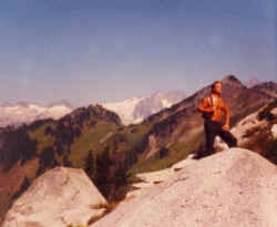
Green Mountain To get to Green Mountain find the Suiattle River Road midway between Rockport and Darrington, go east and in about 19 miles go left on the Green Mountain Road, in 6.2 miles you'll be at the trailhead. You'll see a sign that says "Meadow 1 mile: Lookout 4 miles". Green Mountain is so named because it is so green with one of the lushest wildflower covered meadows you'll find in the Cascade Mountains. The lookout is well-maintained. The view is one of the best of the Cascade Mountain hikes. You're deep in the Cascades here surrounded by the sea of peaks you see when you look east from the summit of Mount Pilchuck. You look out at the Glacier Peak Wildnerness Area with a real good view to the southeast of the Glacier Peak volcano, the least seen of the Washington volcanoes. To the north you see Buckindy Ridge and Snowking Mountain. Downey, Pugh, Whitehorse and Sulphur Peaks are among the peaks you see from here. Looking down you are peering into the Suiattle, Mill Creek and Downey Valleys. The hike is 8 miles round trip with an elevation gain of 3200 feet. |
||
|
|
Hidden Lake & Hidden Lake Peak
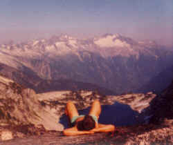
The writer of these words taking a rest on Hidden Lake Peak, near the no longer used fire lookout, deep in the North Cascades near the boundary between Mount Baker Snoqualmie National Forest land and North Cascades National Park. The view here is looking east. The fire lookout is now maintained as a shelter for work parties and any hikers who want to use it. From Hidden Lake Peak on a clear day you can see the elusive Glacier Peak volcano and the less elusive, but much more distant Mount Rainier. You can find the specific directions to the Hidden Lake trail in any good Northwest trail book. You get there via the North Cascades Highway, exiting at Marblemount, crossing the Skagit River on the road that ends at the trailhead to the Cascade Pass Trail, arguably the most spectacular hike in the North Cascades, a hike that ends in splendor in Stehekin. But the turnoff to the Hidden Lake trailhead is only a few miles after you cross the Skagit River. Get a guidebook. The Hidden Lake trail is 3.9 miles long, with an elevation gain of 3,400 feet. |
||
|
|
Cascade Pass You can hike Cascade Pass from either side of the mountains, hence pass being part of the name. This route was studied as the possible pass route when the North Cascades Highway was built, but it was deemed to be to difficult to engineer. That and it would have damaged incredible scenery. From the east you get to Cascade Pass via, most likely, a boat, again, most likely in the form of The Lady of the Lake I or II, taking a leisurely float up Lake Chelan to the village of Stehekin. From Stehekin you can find transport up the Stehekin Valley on Stehekin Road til you reach the end of the road at Cottonwood Camp, where your hike up Cascade Pass begins. |
||
|
|
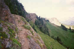
To hike Cascade Pass from the west you exit North Cross State Highway in Marblemount, take the road that crosses the Skagit River. Impossible to miss. And the next direction is even easier. Just drive the road to its end. The further east you go the deeper you are getting into the heart of the Cascades. Soon you are in North Cascades National Park. There is a large parking lot at the trailhead. The trail is in the trees for the first couple miles with 33 switchbacks taking you ever higher until you break out of the forest to views like you see here. You are surrounded by peaks including Hidden Lake, Sahale, Eldorado (which we are looking at here), Forbidden,Ā Mix-up, Booker, McGregor, Johannesburg Mountain, Glory Mountain, Tripper Mountain, Magic Mountain and more. When you reach the summit from the west you'll have hiked 3.7 miles, from the east, 5.4 miles. At the summit you are rewarded with incredible views. And there are trails from the summit tempting you to go further and explore higher.Ā | ||
|
|
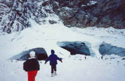
Ice Caves There is a road called the Mountain Loop Highway that goes from Darrington to Granite Falls. This road is in the Mount Baker Snoqualmie National Forest. It is the way to Glacier Peak which is one of the 5 volcanoes in Washington, and the least known and most difficult to get to. The Mountain Loop Highway is very close to the lowlands of Puget Sound and is easy to get to and closer than going up to the ski areas on Stevens or Snoqualmie Pass in search of snow to play on. There are many attractions on the Mountain Loop Highway, Mount Pilchuck, Granite Falls (the actual falls, not the town),Ā Monte Christo, an old mining town which is now a ghost town and a major mountain biking and hiking destination in summer and a cross country skiing destination in winter. But the most unique thing on the Mountain Loop Highway may be the Ice Caves which form every year as the winter's accumulation of snow that has slid off the mountain forms caves as water erodes the ice away. The Ice Caves are about a mile hike from the Highway. There are warning signs. 'Enter the Ice Caves at your own Risk', 'Ice Caves Dangerous on Warm Days'. People have died in the Ice Caves.Ā |
||
|
|
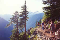
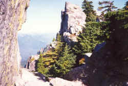
Mount Pilchuck What you are looking at here is near the top of the aforementioned Mount Pilchuck. The trail can be a bit muddy for the first mile or so. In less than another mile you break out of the forest onto granite. There really is not a trail at this point. You follow yellow markers to the summit. The final ascent to the lookout can be a bit difficult. As the lookout comes into view you have two choices in how to get there with one being a class 2 rock scramble that you likely want to avoid, unless you like that sort of thing. The other option is a bit longer and involves climbing over fewer rocks to get to the top.Ā |
||
|
|
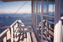
This is the Mount Pilchuck Lookout with its greatĀ 360 degree Cascade Mountain panorama. A good payoff for a long hard 3 mile hike with great views of the entire Puget Sound, a view not seen when you are deeper into the Cascades. On a clear day you can see the Space Needle. You can see Mount Baker to the north, Glacier Peak to the east along with the Cascade Crest, the ridge of all the mountain peaks of the Cascade Range that looks sort of like waves on the ocean. The summit of Mount Pilchuck is 5300 feet above sea level. The trail starts at 3100 feet above sea level. You can calculate how much elevation you gain on this hike yourself.Ā | ||
|
|
Mount Si Near the top of Mount Si looking down on North Bend and Interstate 90. You can see Seattle 40 some miles to the west. I've never actually made it to the absolute summit of Mount Si because that involves climbing up this rock formation called The Haystack. Mild acrophobia makes doing this look scary. Some tourist info claims Mount Si is the most climbed mountain in the country. Don't know if to climb a mountain means you absolutely have to go to the absolute top. |
||
|
|
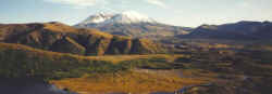
Mount St. Helens
What remains of Mt. St. Helens. The road into Mt. St. Helens National Monument is a feat of engineering that is an adventure all on its own. Then you add that it is taking you to one of the most incredible places on Earth, the recovering desolation zone of the 1980 Mt. St. Helens eruption. Each of the 5 visitor centers on the way to the heart of the mountain is worth a visit with the final one being the best with its look right into the crater of the volcano. |
||
|
|
Mount St. Helens is in Gifford Pinchot National Forest. The view here is from the northwest side of the volcano. Spirit Lake and the Spirit Lake Highway, which is where the visitor's centers are located, are below the location we are at here. This photo was taken before Spirit Lake Highway was built. Until that occurred, access was via logging roads and rebuilt roads. When you entered the blast zone, it was stunning, as nothing had come back to life yet in the blast zone. You drove through thick healthy forest, turned a corner and faced utter destruction.Ā | ||
|
|
|||
|
|
|||
|
|
|||
| Cascade Mountain Links | |||
|
|
|||