|
|
|||
|
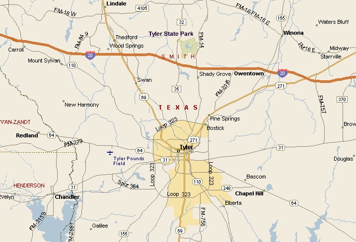
TYLER AREA MAP |
|||
|
Tyler Texas is located a short distance south of
Interstate 20. If you are coming from the east, exit on to Highway 271 and you'll come to Tyler in about 10 miles. Highways 110, 64, 31, 155 and 35 all take you to Tyler. Tyler is about 100 miles east of the Dallas/Fort Worth Metroplex, about 90 miles west of Shreveport, Louisiana. |
|
||
|
|
|||
|
Tyler Transit run buses daily except for Sundays and
holidays. Tyler Pounds Regional Airport connects to Dallas-Fort Worth
International Airport with American Eagle and to George Bush
Intercontinental Airport, in Houston, with Colgan Air Continental
Connection. |
|||
|
|
|||
|
|||
|
|
|||
|
Visit
our Eyes on Texas Blog to make a comment or share info about Tyler |
|||
|
|
|||
|
|
|||
| HOME TEXAS TOWNS PARADES | |||
|
|
|||
| BIG BEND COUNTRY | |||
| GULF COAST PINEY WOODS | |||
| PRAIRIE & LAKES HILL COUNTRY | |||
| SOUTH TEXAS PLAINS | |||
| PANHANDLE PLAINS | |||
|
|
|||
| Conroe Huntsville Jefferson | |||
| Nacogdoches Marshall Gilmer | |||
| Rusk Tyler Kilgore | |||
| Big Thicket National Preserve | |||