|
|||
|
|
|||
|
SCROLL DOWN TO SEE BRYCE CANYON PHOTOS |
|||
|
A little time passed. We helped Jack and Lulu load the heavy stuff, like coolers into their Izuzu, actually Ed did the heavy lifting. I just offered direction. And then it was time to go our separate ways. A round of hugging took place. Very unseemly. I begged Lulu to come with us, as that was the original plan. I'd even left in a seat for her, but I didn't really want her to come with, and she wanted to get back to Gig Harbor for some Easter Egg Hunt or some like thing. So we all started our engines. I went south into town. I assume Jack and Lulu went north. I had planned on going back up to Arches and hiking into Delicate Arch, but once in the van and on the road it just sounded fun to be on our way. We stopped in at the Town Market and bought some essentials cuz I knew we would not be back to any sort of town for a few days. I checked my blood pressure one last time. Remember the first nite in Moab when I took my blood pressure and both the systolic and diastolic were in the high range? After a week of Moab both numbers were in the normal range! Or after a week of Lulu, I'm not sure what is the real cause. The Safari Van was empty of petrol so a fillup had to take place after vittles and such were bought at the Town Market. The ubiquitous jeeps had all the gas stations suffering lines, but the Texaco had an open pump, probably cuz the price was the highest, a buck and a half a gallon or more. The oddest little truck was pumping next to me. With all these jeeps and evil looking jeepers everywhere, this guy had this elaborate drawing painted on his rear window of a little boy peeing on a jeep. So full of gas in more ways than one, it was time finally time to leave town. 10 AM. |
|||
|
The road south of Moab is Highway 191 (for all you readers who
follow these missives map in hand). Just south of Moab, about 5 miles, there
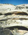
is a bizarre little tourist thing called 'The Hole in the Rock'. It is a
hole in a rock. And inside this hole is a house and a big souvenir-museum
sort of place. Outside the entry is a large carved bust of FDR attached to
the redrock. I do not know why. I can't believe FDR ever did much biking or
hiking in the area. A little further down 191 you pass Wilson Arch, just a
few feet off the road. I mention this because I have driven this road at
least 5 times. This is the first time I ever saw that arch. This vexed me
til I realized this was the first time I ever drove the road south. Heading
north the arch is blocked from view, especially if you are driving at a high
rate of speed and happen not to look to your right at the exact key moment.
A bit further and we passed the Needles entrance to Canyonlands NP. I intend
to go there next visit to Moab. Driving south the scenery is classic
southern Utah. Moab is actually on the northernmost fringe of the classic
zone, of which all is incredible, all preserved, for the most part, via
state land, federal land and National Parks. At the tired little town of
Blanding we were 92 miles from Mesa Verde, Colorado. Having not seen this
premier example of Anasazi Ruins I was sorely tempted to alter my plans, but
I knew that would lead to Taos, then Chaco, then Canyon de Chelly and so I
stuck with my original plan and switched off of Highway 191 on to Highway 95
to begin our turn west. Highway 95 goes thru spectacular redrock and Painted
Desert vistas. Just a few miles out of Blanding there is an exit which said
'Indian Ruins'. I suspected Anasazi, so I thought it click a thumbnail to get the BIG picture Back on the road we passed the turnoff to the Moki Dugway, and then Natural Bridges National Monument. We skipped Natural Bridges, having previously seen it and having seen enough arches and bridges for awhile. As we got closer to Lake Powell the landscape grew more Glen Canyon-Lake Powell-like, which I guess was to be expected. My plan was to check out the marina at Hite, cuz that is where I planned to launch the next houseboat expedition. So we turned into Hite. It was a major disappointment. Very small, not developed at all. None of the amenities we had experienced and enjoyed at the Bullfrog Marina. And Lake Powell is puny at Hite and the water suffers from the silt input of the White River, it is not the clear blue that it becomes further downstream. Hite is a definite no-no. This point on Highway 95 is called Hite's Crossing, a couple bridges take you across White Canyon, then Glen Canyon and Lake Powell. Twenty or so miles more and we passed the turnoff to Bullfrog. Now the scenery was sort of eastern Washington drab. But not for long. A few miles more and Hwy 95 passes thru Hanksville where we took a left onto Highway 24, heading towards Capitol Reef NP. Just out of Hanksville the land turns black and grey. Totally lunar. The locals name their stuff after the lunar landscape, as in Lunar Cafe, Lunar Campground, Moon Inn. We passed quickly thru Capitol Reef. My intention was to go onto Torrey just outside the west entrance to the park, get a motel, then return to Capitol Reef and ride bikes up a canyon we'd driven our van's up the year before. Once in Torrey a motel I remembered as looking cool was now rundown, closed and suitable for Norman Bates and his mother. A Best Western had been built across the street. On the main drag of Torrey, this cute little town with a creek running beside the road, I stopped at a motel where I'd stopped before to photograph an Indian thing. Went inside to check-in. No Vacancy. Everything in town is all booked she tells me, has been for months. I said, but we are in the middle of nowhere, how can that be? She said, 'you're here honey, it's Easter, it's the start of tourist season, you ain't gonna find nothing'. Then she offered that the Aquarian Inn up the road a bit in Bicknell still had room, nice place, she'd never heard no complaints. I was a little concerned about something called Aquarian, fearing aging Flower Children, or worse. I should have been so lucky. So she dialed the Aquarian and handed me the phone, a gruff biddy answered, 'sure we got a room', so I said I'd be right there. It was another 10 miles west. Checked in. |
|||
|
The Aquarian Inn was very odd.
When I walked up the stairs to the second floor and found Room #5, the door
was open. The maid was just cleaning the room, a new girl in training. The
girl asked where we were from. She asked why anyone would want to stay in
this town, that she just wanted to get out. I lied and told her it was a
nice little town. So the maid finished her thing, so I could survey the
room. It was huge. You could fit five 6 Motel rooms in it. I opened the
bathroom window and a horse was staring back at me. And I was on the second
floor. But out of the window I also saw these trails leading out of town, up
to the cliffs that hovered above. I knew we were now 30 miles out of Capitol
Reef. I decided to bail on the Capitol Reef bikeride and ride the trails I
saw out of my bathroom window. The ride was fun enough, but somehow I
managed to get a flat tire. Once back in the Aquarian Inn it was time to go to the Aquarian Cafe. By the way, things are named Aquarian because the area is situated on the Aquarian Plateau, so the name was geologically derived, not hippie derived. The cafe was very odd. It served as the motel office, a video store, the town candy store and a restaurant, with your waitress performing all functions. She interrupted her waitressing to answer the phone, book a room, take back a video and to sell a dirty little rug rat a Snickers bar. I asked her what the cafe cooked especially well. She laughed. I was very nervous of anything at all redmeaty, or at all requiring fresh ingredients. I opted out for something frozen that I knew they couldn't have prepared from scratch. Fish and Chips. But it came with the homemade soup. How bad could that be, I thought? Yuk, it was called Aquarian Goulash and that's just what it was. I think some noodles had been thrown into cans of tomato soup. Ed ordered the Sliced Beef dinner. With vegetables. The chips of my dinner were al dente to be generous. I told my waitress that my fries weren't quite done, she told me that's how we cook them here. I was hungry so I ate the semi-raw spuds. The fish seemed cooked, but it was a bit tepid near the center. I felt like a fish out of water and didn't have the courage to be fussy in this place. The old lady who ran the joint looked as if she packed a sawed off shotgun under the counter. I could go on about the decor, but I gotta remember this isn't the book version of this story. Suffice to say it was very interesting. Ed's Beef Dinner turned out to be huge and very good. When the waitress asked how every thing was, I managed to convey that my fish sucked. She told me I should have ordered the beef, that I should have been clued by all the cattle surrounding the town. Do you see an ocean nearby, she asked? Then she convinced us to order homemade pie. Apple or Cherry. I ordered cherry. Ed the apple. The pie was good but mine was rhubarb-strawberry, not cherry. I won't describe the waitresses frustration when I pointed this out to her. That nite in the Aquarian Inn we watched a very good X-Files, very suitable for viewing in a huge room on the second floor of a creaky wooden structure that swayed every time anyone climbed the stairs. After X-Files there was a Stooges Marathon on Nickolodeon. It was very funny. At some point I passed out and slept except for startling wakeups caused by the shaking-swaying motel. |
|||
The next morning it was back to the Aquarian Cafe for
breakfast. They did breakfast well. And then it was time to leave Bicknell
to begin the drive toward Bryce Canyon NP on Highway 12, the number one
thing I'd been looking forward to on this trip, the highway some consider
the most scenic in America if not the world. So it was back to 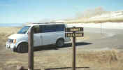 Torrey to the
Highway 12 junction, then south. The first part of the road just gains
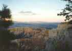
elevation. 7000 feet. 8000 feet. Then the summit at 9400 feet. There was
some snow surviving in places. At the summit the view extended over 200
miles to the LaSalles, to Navajo Mountain in Arizona, to Glen Canyon, to
Lake Powell. It was an impressive view. At the downside of the summit we
came to the little town of Boulder, the last settlement in continental
America to receive daily postal service. In Boulder is Anasazi Village State
Park. It was a nice museum and archeological dig. No Mesa Verde. But I
bought a cool faux petroglyph. The reason Boulder did not receive regular
mail is because of the rather treacherous roads in and out of town. During
the Great Depression the CCC built the new highway, the one we were driving,
Highway 12. It was considered a monumental engineering feat in its day and
was quite controversial Torrey to the
Highway 12 junction, then south. The first part of the road just gains
elevation. 7000 feet. 8000 feet. Then the summit at 9400 feet. There was
some snow surviving in places. At the summit the view extended over 200
miles to the LaSalles, to Navajo Mountain in Arizona, to Glen Canyon, to
Lake Powell. It was an impressive view. At the downside of the summit we
came to the little town of Boulder, the last settlement in continental
America to receive daily postal service. In Boulder is Anasazi Village State
Park. It was a nice museum and archeological dig. No Mesa Verde. But I
bought a cool faux petroglyph. The reason Boulder did not receive regular
mail is because of the rather treacherous roads in and out of town. During
the Great Depression the CCC built the new highway, the one we were driving,
Highway 12. It was considered a monumental engineering feat in its day and
was quite controversial  because of the costs and because locals did not
think a road could be built where they proposed building it---over the
infamous Hog's Back, along a narrow crest, with multi thousand foot drop
offs on either side. As you drive along, the Hog's Back sorta pops into
view. I was so grateful Jack and Lulu had to get home and weren't along for
this part of the ride because it would have been uglier than their panic at
the Moki Dugway. The road is paved, obviously, but there are no guard rails.
The road twists and turns and goes up and down, roller coaster-like for 3
miles. I liked it very much. After the most dramatic part of the roller
coaster section you begin a descent along steep cliffs til you reach the
bottom of Calf Creek Canyon, site of the number one thing I wanted to do
that day on Highway 12, hike to Calf Creek Falls. because of the costs and because locals did not
think a road could be built where they proposed building it---over the
infamous Hog's Back, along a narrow crest, with multi thousand foot drop
offs on either side. As you drive along, the Hog's Back sorta pops into
view. I was so grateful Jack and Lulu had to get home and weren't along for
this part of the ride because it would have been uglier than their panic at
the Moki Dugway. The road is paved, obviously, but there are no guard rails.
The road twists and turns and goes up and down, roller coaster-like for 3
miles. I liked it very much. After the most dramatic part of the roller
coaster section you begin a descent along steep cliffs til you reach the
bottom of Calf Creek Canyon, site of the number one thing I wanted to do
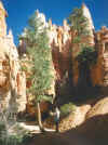
that day on Highway 12, hike to Calf Creek Falls.The trail head for the Calf Creek Fall hike is right off the highway, beginning in a rather nice campground which I was surprised to find full, as well as an almost full trailhead parking lot. The temperature in the canyon was in the 80's, at least. I was glad I was in shorts and sunscreen. It is a 3 mile plus hike to the falls on an easy sandy trail which meanders along Calf Creek. The canyon is very much like Zion Canyon. The creek was dammed by at least 15 large beaver dams. The water was the sort of clear I didn't know water could be, giving a very amazing view of all the trout avoiding being caught by the guys fishing. Along the trail there are many points of interest, Anasazi ruins, a couple arches, odd vegetation, lizards, snakes. About mile 2 the canyon narrows, you begin to hear the sound of water rushing. I thought it was the falls, but it was a giant beaver dam making a spillway. The canyon continued to narrow, and grow steeper, blocking out the sun. We rounded a bend and the sound of a waterfall became unmistakable. 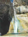 And then you saw it.
Falling a couple hundred feet into an emerald pool, Calf Creek Falls was far
more than I'd expected, creating a sort of tropical oasis in the Utah
desert. A large sandy beach of redrock sand had multiple sun bathers and
occasional quick dippers into the cold water. The swamp cooler effect of the
falls dropped the temps to a very pleasant breezy warm. A local told me the
falls run all summer long, draining a snow melt lake 7 miles further up the
creek. In summer the beach and emerald pool become a very popular swimming
area. The hike back to the van was much warmer, facing into the sun. Ed was
in long pants and was in swelter mode. By the time we reached the van I was
ready to be air-conditioned, but once moving, the open windows provided
sufficient cooling, ending the only moment the entire trip in which I was
tempted to turn on the air conditioner. And then you saw it.
Falling a couple hundred feet into an emerald pool, Calf Creek Falls was far
more than I'd expected, creating a sort of tropical oasis in the Utah
desert. A large sandy beach of redrock sand had multiple sun bathers and
occasional quick dippers into the cold water. The swamp cooler effect of the
falls dropped the temps to a very pleasant breezy warm. A local told me the
falls run all summer long, draining a snow melt lake 7 miles further up the
creek. In summer the beach and emerald pool become a very popular swimming
area. The hike back to the van was much warmer, facing into the sun. Ed was
in long pants and was in swelter mode. By the time we reached the van I was
ready to be air-conditioned, but once moving, the open windows provided
sufficient cooling, ending the only moment the entire trip in which I was
tempted to turn on the air conditioner.
|
|||
|
click a thumbnail to get the BIG picture |
|||
Continuing on we entered the
Escalante zone of Highway 12, following the Escalante river, crossing it a
couple times, before the river finally left us and headed down to become
Escalante Canyon, the coolest side canyon of Lake Powell. This was a narrow
canyon, redrock zone, lottsa slick rock. We dropped down into a flat area in
the center of which sat the little town of Escalante, a charming slightly
Winthropized wild westy town with competing town stores on opposite sides of
the street. I gave each store a little business. Ed bought his usual
two-fisted ice cream bars and I got a bag of smart corn. Out of town the
road climbs again, entering a different geological zone, white slick rock
and then we started seeing the pink hints of Bryce. At the summit an
overlook viewed Powell Point, a white rock desolate escarpment named for
Powell cuz it was the furthest north he got in his explorations and he wrote
poetically about the desolate beauty of this monolith. Now the road became a
downhill to a broad valley, the Tropic 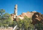 Valley, so named cuz of its lower
elevation actually allowing the cultivation of gardens. We drove into
Kodachrome Basin State Park and did the scenic loop. A very nice campground,
but it seemed like a Bryce wannabe, so I just wanted to get to the real
thing, another 20 miles or so. Continuing on we passed through the little
town of Tropic, Bryce Canyon was clearly visible a short distance away, then
we entered the Park, then came to the left turn and then there was Ruby's
Inn where I'd called to make a reservation the nite before. Ruby's Inn is
now a Best Western, but the Ruby family still owns it. Old man Ruby bought a
ranch here in the early 1900's. A neighbor dropped by and took the Ruby
family on a Sunday picnic to the edge of Bryce. Ruby saw the tourist
possibilities, began running tours, opened an inn, gave up ranching. When
the government decided to make it a national park Ruby was given the park
concession, hence the cozy relationship Ruby's Inn has with the park to this
very day. Ruby's Inn is huge. Our room faced a lake. The complex sort of
sprawls all over. The main lodge has a huge restaurant. The first nite we
had cheeseburgers. The gift shop was mall-like in its hugeness. Ruby's Inn
runs the area's only post office. I don't remember much of that nite. Valley, so named cuz of its lower
elevation actually allowing the cultivation of gardens. We drove into
Kodachrome Basin State Park and did the scenic loop. A very nice campground,
but it seemed like a Bryce wannabe, so I just wanted to get to the real
thing, another 20 miles or so. Continuing on we passed through the little
town of Tropic, Bryce Canyon was clearly visible a short distance away, then
we entered the Park, then came to the left turn and then there was Ruby's
Inn where I'd called to make a reservation the nite before. Ruby's Inn is
now a Best Western, but the Ruby family still owns it. Old man Ruby bought a
ranch here in the early 1900's. A neighbor dropped by and took the Ruby
family on a Sunday picnic to the edge of Bryce. Ruby saw the tourist
possibilities, began running tours, opened an inn, gave up ranching. When
the government decided to make it a national park Ruby was given the park
concession, hence the cozy relationship Ruby's Inn has with the park to this
very day. Ruby's Inn is huge. Our room faced a lake. The complex sort of
sprawls all over. The main lodge has a huge restaurant. The first nite we
had cheeseburgers. The gift shop was mall-like in its hugeness. Ruby's Inn
runs the area's only post office. I don't remember much of that nite.The next morning, Easter, we had the All You Can Eat Buffet Breakfast, served by cowboys and cowgirls. Best waffles I've ever had. It was at this morning feeding that I realized we were one of the only English speakers around, except for workers. Germans Germans everywhere. The sort of Germans that make you think of Nazis and concentration camps, all guttural and loud and slobby and dressing scary. There were French, too, and some Israelis. I now know what it is like to be in a country where your native tongue is not spoken. |
|||
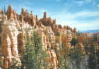
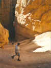 After
breakfast we drove into Bryce, into the Sunrise Point overlook, hiked
down the Navajo Loop trail I'd hiked years ago. At 8000 plus elevation
you feel the lack of oxygen. The Navajo Loop begins with a series of
steep switchbacks dropping you down 480 feet to a narrow canyon only 10
or so feet wide. It is pink and red and orange and sort of glows
incandescent as if the rocks themselves cast off the light. The trail
draws you on due to the otherworldliness of it. After a mile or so we
reached the Peekaboo Loop trail junction, took it, a half mile connector
to After
breakfast we drove into Bryce, into the Sunrise Point overlook, hiked
down the Navajo Loop trail I'd hiked years ago. At 8000 plus elevation
you feel the lack of oxygen. The Navajo Loop begins with a series of
steep switchbacks dropping you down 480 feet to a narrow canyon only 10
or so feet wide. It is pink and red and orange and sort of glows
incandescent as if the rocks themselves cast off the light. The trail
draws you on due to the otherworldliness of it. After a mile or so we
reached the Peekaboo Loop trail junction, took it, a half mile connector
to 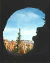 the start of Peekaboo. Peekaboo is a 3 mile loop. Peekaboo is the
funnest trail I have ever hiked, a maze of ups and downs, tunnels,
dropoffs, views. Hiking such distances at these elevations is quite
taxing. We carried no food or water. We began the hike at 9, it was
almost noon before we made it back to the Navajo Loop and began the
upward switchbacks. Back at the van water was consumed and then we drove
to the very end of the park, at almost 10,000 feet there was plenty of
snow. We stopped at every overlook on our return toward Ruby's Inn. Once
back at the Inn it was lunch and nap time. After a rest we went back to
Bryce to go to Sunset Point. Ed hiked Queen's Garden while I absorbed
Inspiration Point. I think I was nearing some
the start of Peekaboo. Peekaboo is a 3 mile loop. Peekaboo is the
funnest trail I have ever hiked, a maze of ups and downs, tunnels,
dropoffs, views. Hiking such distances at these elevations is quite
taxing. We carried no food or water. We began the hike at 9, it was
almost noon before we made it back to the Navajo Loop and began the
upward switchbacks. Back at the van water was consumed and then we drove
to the very end of the park, at almost 10,000 feet there was plenty of
snow. We stopped at every overlook on our return toward Ruby's Inn. Once
back at the Inn it was lunch and nap time. After a rest we went back to
Bryce to go to Sunset Point. Ed hiked Queen's Garden while I absorbed
Inspiration Point. I think I was nearing some 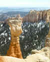 sort of nirvana bliss. Then we checked out the National Park Lodge and
then drove to the Bryce Rim Trail and hiked the rim for two miles to
Bryce Point which is closed due to a massive slide, but we went out on
the overlook anyway. By now the sun was setting, creating a spectacular
light show in the canyon. The walk back along the rim was a little scary
with the creeping darkness.
sort of nirvana bliss. Then we checked out the National Park Lodge and
then drove to the Bryce Rim Trail and hiked the rim for two miles to
Bryce Point which is closed due to a massive slide, but we went out on
the overlook anyway. By now the sun was setting, creating a spectacular
light show in the canyon. The walk back along the rim was a little scary
with the creeping darkness.
Back at Ruby's Inn we buffeted again. Ed was starved so he did the Easter Dinner buffet. I was not starved so I had a turkey sandwich. It had been the best day of hiking and sight seeing I had ever had, which covers a lot of territory over a lot of years! Which likely makes it the best Easter of my life. If it weren't for all those annoying Germans everywhere. click
a thumbnail to get the BIG picture |
|||
|
|
||
|

|
||
|
The next morning, buffet breakfast again, a quick
checkout, a gas fillup and then bye bye Bryce with a resolve to return soon
and stay longer. Out of Bryce and back on Highway 12 the road enters Red
Rock Canyon. This canyon was the first red rock I ever saw, over 2 decades
ago, and my reaction to it then is what likely is the cause for my
continuing consideration of southern Utah as my favorite place on the
planet. Red Rock Canyon is only a few miles long, it is not a deep canyon, a
large creek runs along the road, with the road passing through a couple Red
Rock tunnels, which were the last arches we would see on this trip, manmade
arches, but arches nonetheless. As you leave the low mountain range, which
Red Rock Canyon slices, you drop down into a flat plain in the middle of
which sits the town of Panguitch, yet one more town with a boarded up old
movie house, replaced by the ubiquitous video renters. In Panguitch we
stocked up on vittles, this being the first reasonably sized town we'd seen
since Moab. At Panguitch Highway 12 ends at the junction with Highway 89. We
took the right option, heading north 15 miles to turn off on Highway 20, an
old two-lane which traverses a steep narrow mountain range on the west side
of which we came to the first of what would be mile after mile after
hundreds of miles of open cattle range. Future hamburgers everywhere.
Especially on the road. 20 miles of Highway 20 and we were on a freeway for
the first time in a long time! Interstate 15 for 15 miles to the town of
Beaver and an exit to Highway 21. I looked forward to Highway 21 because of
a spot on the map called the Frisco Mine Ghost Town. This was continuing
cattle country, with only two towns on the road, Minersville and Milford.
Both with the usual dead movie houses, but plenty of video renters. Milford
seemed fairly prosperous, albeit incredibly isolated. Out of town there is a
bizarre construction, like a scaled down nuclear plant, next to the multiple
rail lines. We figured it might be some mega burger processing plant. There
was something oddly unsettling about this town of Milford. It looked too
prosperous for its location. I suspect it may be the place where secret
government witnesses are relocated to. Out of Milford the road climbs to a
low summit. It is at this summit that the ghost town of Frisco sits. One
would not know this from any signage. Just the word Frisco on an old rusted
hulk of a water tank clued us as to this being the ghost town. It was just a
tad to ghostly for my tastes so I drove on. After 50 more miles or so we
crossed into Nevada. One could tell one was in Nevada, not by the appearance
of a slot machine, or a showgirl, but by the lowering of road quality and
the incredible look of poverty in the rundown little town of Baker just
across the border. Just a bit out of Baker, Highway 21 junctions with
Highway 50, the infamous Loneliest Highway in America. Mount Wheeler of
Great Basin National Park, site of Lehman Cave, hovers over the Loneliest
Highway at this point. The road climbs steeply up whatever range Mount
Wheeler is part of, then you drop down into the valley in which Ely sits.
Ely is a nice town with a classic main street. Ely serves as the big city
for a huge area of eastern Nevada and western Utah. Had great Mexican food
there on a previous visit, but I digress. This trip we didn't even enter Ely
proper. There is now a McDonald's at the fringe of town at the exit off the
Loneliest Highway, Highway 6 to Tonopah, new highway which I'd never been
on, unlike the Loneliest Highway, which I had previously been lonely on. Ed
did his two-fisted McDonald's ice cream cone thing and then back on the
road. Highway 6 seemed like Highway 50, only more lonely. It crosses the same mountain ranges, the same valleys, only it sort of goes at a southwest diagonal. The road was very relaxing, no traffic, telephone poles lined the side of the road on into the distance. It was hypnotic and I grew sleepy. I took a couple Vivarin to no effect. Finally the warm winds and the lulling road made me decide I should pull over and nap. At a wide spot I did so. For a half hour at midday, no vehicle disturbed my napping, a napping complete with dreams, which is very bizarre, cuz usually I never take naps, much less on the side of highways. Once rested I was able to drive without a problem, despite those vexingly hypnotic telephone poles marching with a rhythm as far as the eye could see. After 150 miles or so it was apparent civilization of some sort was nearing. A large airport, and a military base. Nellis Air Force Base. And then a godforsaken helterskeltered mobile home camp, with a sign, 'Welcome to Tonopah, Home of the Stealth 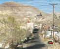 Fighter'. I
feared I was hallucinating from that dose of Vivarin. It seemed so unlikely
that the Stealth Fighter could have come from that mobile home camp. But
just around the bend in the road the rest of the burg of Tonopah came into
view. Yikes. The town had mine shafts all over town. The main drag was a
desolate zone that had a post-war look to it. Maybe it had been bombed by
one of those Stealth Fighters. But this is where I planned on staying, and
the motels were numerous and all were bragging cheap rates trying to snap up
the few suckers unfortunate enough to be staying overnite. Fighter'. I
feared I was hallucinating from that dose of Vivarin. It seemed so unlikely
that the Stealth Fighter could have come from that mobile home camp. But
just around the bend in the road the rest of the burg of Tonopah came into
view. Yikes. The town had mine shafts all over town. The main drag was a
desolate zone that had a post-war look to it. Maybe it had been bombed by
one of those Stealth Fighters. But this is where I planned on staying, and
the motels were numerous and all were bragging cheap rates trying to snap up
the few suckers unfortunate enough to be staying overnite.The Delta Queen caught my eye. A garish motel built on stilts, with 3 stories hovering over the motel office, which is shaped like a crown painted green with gold pointy things on top. Rooms were 22 bucks a nite, no matter how many people, beds, dogs or whatever. Asked if there were any good restaurants in town the skinny motel lady said the Delta Queen Restaurant was good and there's a Chinese place down the block but be sure to tell them to lay off the grease. I decided to just go find a grocery store. But first I had to finesse the tangled confusion of stairs and passageways to get to the room on the third floor. Once in the room I was quite pleased. It was huge, with giant beds. Double sinks outside the bathroom, and here's the weird part. You could pull a giant sliding door sort of thing and close the sinks and the bathroom off from the rest of the room. There were mirrors all over the room, that flattering sort of mirror that well....at the grocery store I picked up the local paper, the Tonopah Rattler. Huge headline on the front page. 'Madame Flo petitions City Council to reopen Brothel'. Seems Flo lost her license and she had run a very popular establishment. Over 50 supporters were at the meeting. And even one local preacher went on the record as supporting Flo's quest cuz it's just good wholesome fun that don't hurt nobody. Ed and I became determined to find this shutdown brothel. It's not a big town. It seemed like it was not something you could hide. Tonopah, being a mining town, is built on hills, so we went up one side and then the other. We only found one garish looking mansion sort of house that could have been a brothel. It was boarded up though. Probably Madame Flo's was that mobile home camp by the Home of the Stealth Fighter sign. At the grocery store I was amazed, as I always am in Nevada, at the cheap liquor prices. I usually never buy the stuff. But I bought a big jug of vodka. We debated whether or not to buy Wanda some whiskey, but then we remembered that she was just in Nevada herself and likely had bought a huge supply like she did on the return from Lake Powell. Back in the motel I made sandwiches. Then we watched a Sharon Stone movie on Showtime. I think I may have had a sip or two of that vodka. |
|||
|
The next morning we decided to forego any of the
Tonopah breakfast serving establishments and just snack lite in anticipation
of pigging out at the world's best buffet at the El Dorado in Reno sometime
around noon. When I started up the van that morning I saw that the gas tank
was a bit low, but prices in Tonopah were a buck sixty a gallon or more, so
I figured I'd find something cheaper up the road, Highway 95 was the main
drag north from Vegas, there had to be a lot of gas stations I figured, and
I'd only gone 475 miles since the last fill-up, meaning I still had about 75
miles to go before empty. The road out of Tonopah is well traveled, it is
no Lonely Highway. But those towns that you see named on a map are little
godforsaken dustspots of shocking trashiness. Leading into the first
so-called town, named Coaldale you saw the usual speed reduction signs, the
sort I usually ignore when I'm in the middle of nowhere. Coaldale tried to
drop you from 70 to 25, a slow down for a dead town. So I did not slow down
til I rounded a bend and saw a big black and white sitting, poised to take
off and ticket a speeder. Yeah, I slowed way down, real fast. As we passed
the parked cop car we looked to see if he was using radar. No. He couldn't.
Cuz he was a dummy dressed like a cop, complete with sunglasses. A very
effective trick which they repeated on both sides of town. A little ways
further the equally decrepit town of Mina did the same trick. Coming into
the third town, Luning, I was prepared for it this time and just when I
decided to blow thru town at top speed I thought that they might just be
sadistic enough to play a clever mind game and throw in a real cop every
once in awhile. So I slowed down. But it was a dummy-cop once
more. In each of these towns there were no live gas stations. You saw the remnants of gas stations with prices that reflected their age, like 44 cents a gallon. My tank was getting low. The next town after Luning is Hawthorne, 26 miles away. My odometer already showed we'd gone 534 miles since Bryce. I was very concerned, but I figured the worst that could happen was we'd have to ride our bikes into Hawthorne and ride back with gas. Or call AAA on the cel phone. We got in sight of Hawthorne, and then once more the hated 'Road Construction Ahead' sign. We ground to a halt. A possible 30 minute wait we're told. I turn off the engine. We are entering some sort of military area. As far as you could see the landscape is dotted with bunkers where explosives are stored. When we at last began to move again, driving slowly past these explosive bunkers, a lake appeared to the right, a big lake called Lake Walker. And then a sign. Hawthorne Naval Base and Submarine Training Area. In the middle of the Nevada desert there is a navy base with a lake which apparently has submarines in it, all surrounded by buried explosives, miles and miles of buried explosives. Ain't America an interesting country? By the way, I finally did get gas, in Hawthorne, at a Texaco, for the same price I could have paid in Tonopah! The van had made it over 560 miles on one tank of gas! Continuing on I took alternate Highway 95, a sort of short cut to I-80. I got off the road at a town called Wabuska cuz I was thirsty and wanted water. This was on an Indian Reservation, I think, but whatever it was, it was very run down and poor. The outskirts of Wabuska did not greet you with a fake dummy cop. This town had a couple of horrible looking car wrecks with a sign warning about the dangers of drinking and driving. Geez, all I wanted was water. Wabuska was a very depressing place. But back on the road we soon entered an agricultural zone and then came to Fernley and finally I-80 for a quick freeway zip into Reno. |
|||
|
My plan for Reno was to stay at the new casino resort, Silver Legacy,
which had been built since my last visit. Coming into town, Reno looked
different. Silver Legacy is huge with a giant dome in front of it. There
had been several other new hotels added to the skyline. We easily drove
into the Silver Legacy check-in, no rooms, all full, bowling convention.
I should have guessed, cuz I had already noticed little groups of people
all wearing the same garish shirts. So we tried Circus Circus. No
problem. A room high up in the SkyTower, only 28 bucks a nite. Zipped up
to the room, changed clothes, zipped back down, walked into Circus
Circus knowing a skybridge or some like contrivance now connected Circus
Circus to El Dorado with Silver Legacy in between. And so it was. But
not a skybridge. Circus Circus sort of opens up to Silver Legacy in a
big Caesar's Palace Forum Mall type of deal, you walk for a bit, the
ambience growing increasingly opulent, a huge silver mine device pummels
away under that huge dome that is the centerpiece of Silver Legacy. You
keep on walking and then you realize the opulence level has elevated
further and you now know you are in El Dorado. The surroundings seemed
more familiar, and then there it was, looming ahead, the buffet from
heaven, totally remodeled, a new name, no longer the MarketPlace Buffet,
I don't even remember what the new name is. But the buffet is now huge,
the decor replicates being outdoors at a sidewalk cafe with an early
evening sky hovering overhead. You sit at your own private table, the
nearest fellow diner kept a decent distance away. The food was even
better than remembered. I can't go into details cuz I am hungry as I sit
here typing and don't want to think about it. Suffice to say we left
bloated like a pair of waddling fat men, barely making it back to the
22nd floor at Circus Circus, thank god for speedy elevators. I collapsed
on my bed like a swollen slob. I passed out and napped til about 5. When I awoke from my bloated slumber a wind was pummeling the SkyTower. An evil looking storm had blown in. Let's go to Costco, I thought. Costco is just a couple miles away and a bit off Virginia Street. By the time we reached Costco the wind had become a virtual hurricane, swirling dust and litter. Driving into Costco's parking lot I was barely able to have enough time to park the van and rush to stop a careening shopping cart from disabling an elderly shopper. I was hailed as a hero. There were flying shopping carts everywhere, thank goodness they were constructed of plastic. In Costco I scanner shopped and bike shopped. I happened upon the Costco liquor aisle. Gallons of the toxic liquids for bootlegger prices. Once more we debated whether or not to buy Wanda some Whiskey, but confronted with the multiple brands we cowered away from making a choice, and left the store with nothing for Wanda. We felt so guilty. Out of Costco we drove to Lake Virginia where I made a few calls home on the cel phone, one of them being to poor dry Wanda. I told her I'd bought her a souvenir, and I fully anticipated it would eventually be a jug of Whiskey, but none was ever bought, so I gave her a tourist brochure instead. I also called my brother and learned my Uncle Ivan had died. After the phone calls I drove around Reno exploring the southwest side of town up McMarran Boulevard. Saw bike trails that we decided to ride the next day. |
|||
|
Back at Circus Circus it was starting to get dark, time to play in the
casinos. I was looking forward to this because my last 3 times in Sin
Cities I have been hobbled with rubes. The previous visit to Reno being
the one where we rented a Cadillac and I drove Wally, Eddie and Dale for
one nite in Reno en route to Yosemite. Wally wandered around the casinos
with buffet bloat and flatus extremis. Then there was the 4 days in
Vegas after the Lake Powell trip with Jack and Lulu and Wally and Wanda
totally ruining my birthday plans while they went to some dumb Canadian
Circus, not too mention their multiple gaucheries which I found so
vexing. And then there was the flight to Vegas last November, where I
got so tired of moving that somnambulant group of elderly wannabes. So
it was so nice to be in Reno with no infants requiring babysitting. With
this uplifted spirit I had a fun nite going from casino to casino,
losing my nickels, partaking of the local color, and drinking the free
libations. Sometime after midnite I decided it was time to go to the
Nevada Club and Kilroy's Diner for my usual Reno late nite burger. The
waitress was particularly animated and sat on my lap at one point during
the ordering process. Next to us sat a couple Germans. I'll skip ahead
and suffice to say that after awhile I went back to the Circus Circus
and went to bed. The next morning it was back to El Dorado for breakfast buffet. I forgot to mention that when I got back the nite before a note had been slipped under the door offering an extra nite's stay for 20 bucks. An offer too good to pass up. After buffeting, on the slow waddle back to Circus Circus we explored Silver Legacy. It is all of a Victorian theme. Quite well done. The Mine is the centerpiece and a show goes on every hour or so. The sky grows dark, lightning and thunder flash and roar, then the Mine thing comes to life, makes a racket and miners climb it to keep it working, fall off and rescue each other. Eventually it spits out a couple huge silver ingots. What a spectacle. |
|||
|
Back at the Circus Circus a period of breakfast post-rest was required,
then back down to the van to get the bikes to go on a ride. No such
luck. Mine had a flat. I had last rode in Bicknell so that little ride
must have flattened the tire. So we decided to do the Trinity Riverwalk
which starts downtown. It is very well designed, the river was in heavy
snowmelt, being quite wild for a river in an urban setting. The
riverwalk goes on for about 4 miles. By the time we got back to Circus
Circus it was time for another feeding. Uh, El Dorado again. Then back
to Circus Circus for post buffet bloat down. Then later back on the
streets again. I had a humiliating incident at the Circus Midway, where
I paid 2 bucks for a weight guesser to guess my weight within 3 pounds
and if she is wrong I get to pick a prize. She guessed I weighed 210! I
was appalled, thinking I must be looking real fat. Then I got on the
scale and it said I weighed 230! So I was actually fat! I decided right
then and there, one more buffet and then I'm leaving this town. So that
nite we did the casino stuff again and then at some time during the nite
I returned to sleep at the Circus Circus and once more a note had been
slipped under the door, this time offering a third nite at a reduced
rate. This time I decided to pass on the kind offer. The next morning I decided to dare to be different and so we breakfasted in Victorian splendor at the Silver Legacy buffet. It was good, but no Dorado. Back at the Circus Circus it was a quick pack up and go, checked out and hit the road out of town by 11 AM. Next stop Susanville. The Wal-Mart. I won't detail why. Or what I bought there. Out of Susanville we left Highway 395 for the twisty-turny old Highway 139 on to Klamath Falls. The only Highway 139 incident mattering mention, except for the first of two ugly McDonald's brouhahas involving cheeseburgers (avoid the Klamath Falls and Ellensburg McDonald's, or at least do not order cheeseburgers while women are managing), anyway the incident worth mentioning on Highway 139 was at a summit about 40 miles north of Susanville where there was a tree, a Sequoia I think, and on this tree, high up, were tied dozens of shoes, just dangling from their shoestrings. I guessed it to be the work of a yet undiscovered California serial killer. After the ugly Klamath Falls McDonald's incident we continued north on Highway 97, the sky turned grey and northwesty. And then rain, hard rain, and then it turned to snow! The snow stopped by the time we reached Bend where we overnited at a nice little motel on the main drag. The next morning, pancakes at IHOP. They were good, but stay away from pecan syrup. From Bend it was a short jaunt home, crossing the Columbia, entering Washington at the point where Highway 97 is guarded by the Druid Stonehenge replica at Maryhill. Satus Pass was uneventful, and finally I-82, Yakima, the view into the Kititas Valley, all emerald green after a couple weeks of seeing only earthtones. The rain became torrential by the time we hit I-90. It rained all the way home from that point on. I liked it. I called nephew Jason on the cel phone when I reached Skagit Valley, telling him he didn't need to feed Hortense anymore. It was nice to be home. |
|||
|
|
|||
| Roadtrip to Moab | |||
| Sunriver Meltdown | |||
|
|
|||
 At dawn of our last day in Moab, Friday,
Jack and Daniel and Andrew went to the Slick Rock Trail so Jack could take
the photos which Lulu claimed he had been commissioned to take, for which she
claimed he was to be paid sufficiently, enough to pay for their entire trip.
It is widely believed this was a classic Lulu fabrication, but it was an
indisputable fact that Jack and the boys did go to the Slick Rock Trail at
dawn. By the time they returned to the Super 8 we were busy loading up the
vehicles, preparing for our exit. Jack said Slick Rock was freezing cold and
windy, but he got his photos. I can't believe he was up and about that
early, on his bike, after the grueling Porcupine Rim Ride of the day before.
Jack is one skinny, scrawny, tough guy. To look at him you think mega-wimp,
but in actual fact he is an ironman. Being married to Lulu all these years
has toughened him up, sort of like a veteran of a lengthy war.
At dawn of our last day in Moab, Friday,
Jack and Daniel and Andrew went to the Slick Rock Trail so Jack could take
the photos which Lulu claimed he had been commissioned to take, for which she
claimed he was to be paid sufficiently, enough to pay for their entire trip.
It is widely believed this was a classic Lulu fabrication, but it was an
indisputable fact that Jack and the boys did go to the Slick Rock Trail at
dawn. By the time they returned to the Super 8 we were busy loading up the
vehicles, preparing for our exit. Jack said Slick Rock was freezing cold and
windy, but he got his photos. I can't believe he was up and about that
early, on his bike, after the grueling Porcupine Rim Ride of the day before.
Jack is one skinny, scrawny, tough guy. To look at him you think mega-wimp,
but in actual fact he is an ironman. Being married to Lulu all these years
has toughened him up, sort of like a veteran of a lengthy war.